Roads

A short Day trip from Vadodara to Hathnimata Temple & Waterfall

By

From there, the air is very very clean and it’s all Green around !!,You’ll find yourself in typical village area, which lush green paddy fields , huts, etc. but the road is very Narrow at this point, and one must be care full.

Just a word of caution, drive very slow, as it’s village area and lot of children cross the roads every now and then, And try not to use Horns !!! Let’s do our bit not to disturb the locals.

A small Parking area is available, but, recently have seen a small field being cleared for make shift parking area. the Locals charge 5-10 Rs. for that.

Park your vehicles, and move ahead for a short trek over the flowing waters and that will lead you to the Waterfall !!, It’s a good place for Kids and every one. Sply Kids, they would love to see small Fishes in clear waters.

Read More

हिंदुस्तान का नाज़, यक़ीनन ताज….

By

तकरीबन तीन घंटे की स्मूथ ड्राइव के बाद आगरा शहर में दिशा निर्देशो का पीछा करते हुए हम लोग होटल मधुश्री के सामने आकर खड़े हो गए. यमुना एक्सप्रेसवे से बाहर निकल कर जब आप आगरा शहर में प्रवेश करते है तो नाक की सीध में चलते चले जाने से एत्माददुल्ला के मकबरे (किले) की तरफ जाने वाले रस्ते पर एक टी पॉइंट आता है जिसमे यह होटल बिलकुल कोने पर ही बना हुआ है और इस होटल से दो मार्ग जाते है पहला आपको रामबाग, मथुरा, दिल्ली की तरफ ले जाता है और दूसरा मार्ग एत्माददुला और ताज महल की तरफ ले जाता है। इस होटल की एक बात मुझे और अच्छी लगी की आगरा की भीड़ से आप बचे भी रहेंगे और शांति भी बनी रहेगी अन्यथा जैसे-२ आप शहर के भीतर बढ़ते चले जाते है बेतहाशा ट्रैफिक और गन्दगी के ढेर आपको परेशान करते रहते है. और एक बात जिसकी हमे बहुत आवश्यकता थी वो थी कार पार्किंग जिसका बंद गलियो वाले रास्तो पर मिलना बहुत ही कठिन कार्य लग रहा था और एक पल को तो हमे लगा की कहीं हम इस भूल भुलैया में ही घूमते हुए न रह जाये। होटल के प्रांगण में कार पार्किंग का पर्याप्त स्थान मिल जाने के कारन एक मुसीबत तो हल हो चुकी थी और अब बारी थी उस जोर के झटके की जो धीरे से लगने वाला था अर्थात कमरे का किराया। होटल के अंदर स्वागत कक्ष में उपलब्ध प्रबंधक साहब ने बताया की यह होटल अधिकतर बिजनेस मीटिंग्स के लिए ही बुक रहता है जिसमे फॉरेन डेलीगेट्स आकर ठहरते है अतः आपको एक कमरा मिल तो जायेगा किन्तु चार्जेज लगेंगे पूरे पच्चीस सौ रूपए। अब मरता क्या न करता, आगरा के भीतर घुसकर ट्रैफिक से जूझने और कमरा ढूंढने की हिम्मत तो नहीं हो रही थी अतः महाशय को एडवांस में रूम चार्जेज का भुगतान करने के बाद अब हम लोग निश्चिंत होकर ताज देखने के लिए अपनी आगे की योजना बनाने लगे. वैसे यहाँ एक बात और बताना चाहूंगा की साफ़-सफाई और सुविधा की दृष्टि से होटल में कोई कमी नहीं थी, कार पार्किंग के अलावा अलमारी, सोफ़ा, एक्स्ट्रा पलंग, कलर टीवी, एयर कंडीशनर, संलग्नित बाथरूम, फ़ोन व् फ्री वाईफाई जैसे तमाम विकल्प मौजूद थे.

Read More

All about Bhangarh Fort, Rajasthan

By

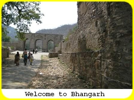
The Mughal connection is attributed to the relationship of Sawai Madho Singh, the ruler of Bhangarh in 16th Century with Raja Mansingh I, who was a general in Akbar’s army. These two chieftains were brother. Their father Bhagwant Singh was the ruler of Amber. This Mughal association is believed to be continued till the death of Aurangjeb. When the Mughal empire weakened, Bhangarh was attacked by Jaishingh II in 1720 AD. Later, a famine broke out in 1783 AD, which forced the inhabitants to abandon the city. However, history apart, the fort premises had the reputation of the haunted place till recent years. And, such reputation became the main reason for the tourist to flow in that sleepy village.

At the first sight, it seemed that the ruins of the fort and residential buildings were scattered all over the place, which makes it difficult to see the important places without any guide. Realising the same, the Archaeological Survey of India had put a reasonably good guide map there. I tried to decipher that map, but could not succeed in the first attempt. I started feeling that such maps could be used only after one visited all over the place and returned to the map only to understand what was what. Anyway, with the help of subsequent attempts at the map, we proceeded towards what was once the jewellery market.

Read More

On the road, from Old Pushkar to Bhangarh, Rajasthan

By

Approximately 10 kilometers before the Jaipur City, we had to take a turn towards the NH 11 C through Gopalpura Bypass. The journey from Pushkar to Gopalpura Bypass was so far good and pleasant. But, I was desperate to have a cup of tea. Suddenly, I saw a tea-shop, where tea was being prepared on the log-wood-stove. An old lady owner of the shop was preparing tea. I could not resist myself and stopped the car to have a cup of tea prepared on the flames of log-wood. I felt as if I were in rural Rajasthan. Sipping that tea from a disposable cup was a different experience altogether. Such tea-shops are a rare luxury these days. But, while standing there, I was also surprised to see the attire of that lady-owner of the eta shop. She was wearing the thick silver bangles, silver necklace and the silver nose-ring. Either she must be quite rich in her community or wearing such ornaments by a married lady must be a tradition here.

The tea had the desired effect on me. With the renewed energy, we came to the Toll plaza of the Jaipur-Agra Expressway. One of the Aravalli hills had been cut for makingthe way through a tunnel. Being a Sunday afternoon there was no rush there. My wife, however, pointed out that it was the same tunnel which was depicted as the most-accident prone area in the Amir Khan’s “SatyamevJayte” programme on the road safety. Anyway, we crossed that tunnel without any difficulty and proceeded ahead and continued to our third leg of the journey.

Read More

Majestic Ladakh : Kargil to Fotu La

By

The monastery is placed at the centre top of a brown mountain cliff and appears as if suspended in the middle of it. A narrow road with many steps will take you inside to this wonderful cave monastery. This monastery has many elegant frescoes. This is one of the old Buddhist monasteries in Ladakh region.

Read More

My visit Utamaduni Craft Centre and Kazuri in Nairobi

By

Utamaduni Craft Centre

My business schedule didn’t allow me to make a voyage to one of the ultimate destinations of Kenya – The Masai Mara. So I decided to explore nearby areas in the next Saturday. We took a taxi (booked by the hotel) and started off for a place named Utamaduni Craft Centre (http://utamaduni.com/). One of the specific reasons to go there because that place specializes in African native crafts and arts, and has a huge collection of all varieties. Reaching there I realized that was indeed a great decision to arrive here – the assortment is really so remarkable. Collected a few souvenirs from there as well.

After spending a couple of hours there, we headed to another nearby place Kazuri Bead and Pottery Factory (http://kazuri.com/). They are supposed to be one of the largest manufacturers of clay made beads and pottery works.

The place is really a heaven for ladies, specially who fancy the jeweleries made of beads and clays.

Read More

Majestic Ladakh : ZojiLa- The Most Treacherous Mountain Pass In The World!

By

Wait a minute! It has a history of war too. Don’t raise your brows! Yes, it has. Kashmir was then an independent Kingdom and Maharaja Hari Singh was its king. It was the year 1947-48. The king was finding it difficult to decide with which country to join his territory, India or Pakistan, or to remain independent. The king chose to remain independent but his wishes were short lived and dashed in October 1947 as Pakistan sent Muslim tribesmen invader into the territory of Kashmir who were then approaching to the capital Srinagar fast. Maharaja Hari Singh signed the Instrument of Accession, ceding Kashmir to India on 26th October. Thus the first war between India and Pakistan broke out over Kashmir in 1947. India referred the dispute to United Nation on 1st January 1948. During this war Pakistani invaders seized ZojiLa in 1948 while they were on the verge of capturing Ladakh. On 1st November, Zojila pass was recaptured by Indian forces under Operation Bison. On 1st January 1949, a ceasefire was agreed with only two-third of the whole Kashmir under Indian control and the remaining with Pakistan (we call it now as Pakistan Occupied Kashmir or P.O.K). In the ceasefire lines, LOC (Line of Control) was drawn up which was formally established in 1972, after a third war between India and Pakistan in 1971.The Line of Control remains the de facto border between the two countries.

We spent enough time at the pass looking at how other vehicles were negotiating the road at the mountain edge that has no barrier. The road is so narrow and vicious that it is known as one of the most dangerous passes in the world. But the route is a lifeline that keeps the people of Ladakh connect with the rest of the world. However it remains closed for more than six months in a year for blockage due to heavy snowfall. The road reopens in late spring. ZojiLa at an elevation of 11649 feet above sea level is considered to be the second highest pass after Fotu La on the Srinagar-Leh National Highway.

Read More

Road to Chandratal

By

We reach Kunzum jot, slightly off the main road and where vehicles take a customary loop to offer prayers. It is an overcast morning…. has continued to be so since Losar. More clouds come rolling in and almost obscure the Stupas at Kunzum Jot. Behind the Stupas and to their right, the track is clearly visible going to Chandratal. As our three vehicles halt there, we see no sign of the advance party. After mulling our options, we decide that one vehicle will go down the Kunzumla towards Batal and check out the motorable road to Chandratal since that is the only other place the other Scorpio could be. Sure enough, in a while we get a message from a tourist vehicle coming from Batal that our two Scorpios are at the motorable road and for us to join them there.

Read More

Spiti…. journey through ‘The middle land’

By

Bypassing such quaint villages as Yangthang, Chango and Leo, we press on for Nako. I have great hope that the cloud cover will disperse enough for Reo Purgyal, the highest peak in Himachal to be visible. Unfortunately, the peaks are all shrouded in thick clouds. We have a very long way ahead and no time to tarry. We do not even swing by Nako Lake consoling ourselves that we would see the Chandratal anyway today and hurry ahead. Far, far below us is the meandering Spiti and the beautiful Leo village is visible low down across the valley.
The route takes us through barren, crumbling mountainsides and the presence of a BRO detachment alerts us to the proximity of the Malling Nallah stretch which is infamous for being a perpetual landslide zone. It does not disappoint. We cross the Malling Nallah and come to a halt behind two other vehicles. A JCB is busy clearing an enormous few ton boulder in the landslide while a steady rain of shooting stones continues. It is scary, to say the least. I guess the BRO knows how dangerous it is and has concluded that this is minor enough for the work to continue. Hats off to these sentinels of the roads in these remote areas!

Read More