
The lesser known destinations: Rakcham – Chhitkul
Recap – This is the last leg of our 08 days trip Delhi – Kalpa – Sangla – Chitkul- Shimla – Delhi. Though Sangla…
Read More Traveling is good
Accessible by road from Shimla, the Sangla Valley or Baspa Valley is one of the most charming valleys in the Kinnaur district of Himachal Pradesh. Sangla village is situated on the banks of the River Baspa quite close to the Tibetan border. The Sangla Valley camp is set up from April to October to serve as an excellent base camp for tourists wishing to discover the rugged beauty of Kinnaur and Spiti valleys.
Treks to view snow covered Himalayan peaks, angling for trout, experiencing some of the local culture and traditions, rock climbing, rappelling and river crossing are some of the delights that the Sangla Valley offers. There are beautiful walks along the Baspa river and to the Sangla meadows and a few quaint temples in the villages are visit worthy.
Best time to visit: April to October
Languages spoken: Hindi, Pahari
Climate: Cool summers and cold winters with heavy snowfall
Adventure tourism: Trekking, Rock climbing, Rappelling, River Crossing
Nature�s Bounty: Chitkul village, Sangla Meadows, Rakcham village, Batseri village, Baspa River
Recap – This is the last leg of our 08 days trip Delhi – Kalpa – Sangla – Chitkul- Shimla – Delhi. Though Sangla…
Read More
Sangla is also famous for Kamru Fort. This fort is like a tower dedicated to Kamakshi Temple. The Goddess idol was brought from Guwahati (Assam). We braced ourselves and took to steep climb of stairs. The climb took us through houses of Kamru village and get a peek into their life. First there is a temple which has couple of shrines in the small courtyard in hill architecture. Their sloping roofs are lined with flat chipped stones tiles and the distinctive cone as the top. The main Kamru fort was still some climb away. Thankfully, it was quite sunny and pleasant for the climb. After some time, the Kamru fort came into view perched right at the top of the village. One has to tie a cloth around waist and wear a cap which is available in the fort to enter the precincts and go around.
Read More
As we go further, this road climbs higher till it reaches sheer cliffs of stark, unadorned rock where the road is but a scooped out C-shaped tunnel embedded in the vertical cliff side. While we enjoy the drive along the banks of the Sutlej in all its moods, I am almost willing the road to start climbing to this, one of the most celebrated and recognised sections of this route. And when we do hit that stretch, we are all spellbound! Such is the precarious nature of the road that there are precipitous drops on the only open side and encased in solid rock on the other three sides.
Read More
The scenes were becoming increasingly breathtaking and that made me even more eager to reach Chitkul. And boy, is it something! The amazing view of the mountains, waterfalls and the river going along. Twice we came to a point where there was no road, and I had to drive my new Indica vista, 1300 cc engine, through water. What an amazing experience! Beautiful valley, river flowing, and an absolutely divine view of the mountains. The view is imprinted in my mind’s eye forever. That’s how mesmerising it was.
Read More
A very important thing about Himachal, is that people are very cooperative and they are very happy with what they are and have. I am writing this because I tour as well as I interact with people over various places, trying to find the differences in the cultures, way of living etc. This is what travelling is all about. I found Himachal people in the remote of the areas to be very well educated (better than what we are in cities) and well behaved. They are clean by heart and they educate their child to be as clean as them.
Soon it was getting dark and we entered the temple which normally opens up after 7PM. Not everywhere inside the temple are cameras and accessories allowed, but there are lockers where they can be kept. So we put our accessories in the lockers and entered the temple. The Bhimakali Temple at Sarahan is quite big and unique in its own way and own beauty. It looks more like a monastery rather than a temple.
Read More
After about two and a half hours we reached Reckong Peo,or Peo, as it is popularly known. Peo is situated at an altitude of around 2200 metres above sea level and is at the base of the Kinner Kailash massif. From here, Kalpa was a short 20 minute drive and by lunch time we reached Kalpa. Our plan was to halt at the PWD rest house, which turned out to be a cottage with an excellent view of the mountains. Staying in Kalpa can be compared to living in the lap of nature. Overlooking the Kinner Kailash range, this is one of the most picturesque hill stations one can ever visit. This quaint town was once the headquarters of Kinnaur district before it was replaced by Reckong Peo. The collector’s office has now been taken over by the HP Irrigation Department while the old SP office is now a small police outpost. The old building of the District Hospital is visible behind the new building of a recently constructed Primary Health Centre. From Kalpa, one can spot the famous Shiva Linga, nestled in the middle of the Kinner Kailash massif. It is a 2 day trek from Kalpa for the strong and sturdy.
Read More
After crossing the dam towards Sangla, condition of road was not very good and it was narrow too, however it was fun driving through this chilling route along with green Baspa. My wife and son were also lost in this beautiful valley but my 13 yr daughter was alert enough to remind me to blow the horn at every blind turn which I think is advisable while driving on hills. Before reaching Sangla my kids were excited enough to peep the scenic beauty through the sunroof.
Read More
03 Oct 2011 Travel to the place Where mind set to peace, No one can see, Feel us free. After a mesmerizing morning in…
Read More
Look closely and you can see the trails of the stars that form the Orion Constellation. No, Just look above the snow capped peak, a bit on the right from the center of the pic and you will see the trails of the three stars that are in the middle of the Orion Constellation. And you can also see a pink colored streak just a little bit on the right of the peak. That is Orion’s Nebula. Didn’t i tell you, i also spotted as much as 9 shooting stars and 1 satellite while capturing the star trails.
Read More
The condition of the road was getting worse by each passing kilometer. The tar road made way to the grainy, rocky road covered by dust. At some of the stretches the water tankers were moving on the road to keep down the dust. Suddenly the roads became never ending and driving getting difficult especially for a lone bike rider all along the way. I kept on driving slowly and crossed Wangtoo, Chooling and reached the Karcham Dam. A right from here would take me off the NH – 22 and put me on the Sangla- Chitkul road. The winds were also picking up and it was getting difficult to stand near the dam. So, i started the bike again to cover the final stretch of the day. The road condition was bad and the way to Sangla was steep and narrow. One slip here and i would have to pay for it with my life. So, with all the concentration on the road and a speed of 10-15 kmph i began the ascent on the hair raising Sangla – Chitkul road.
Read More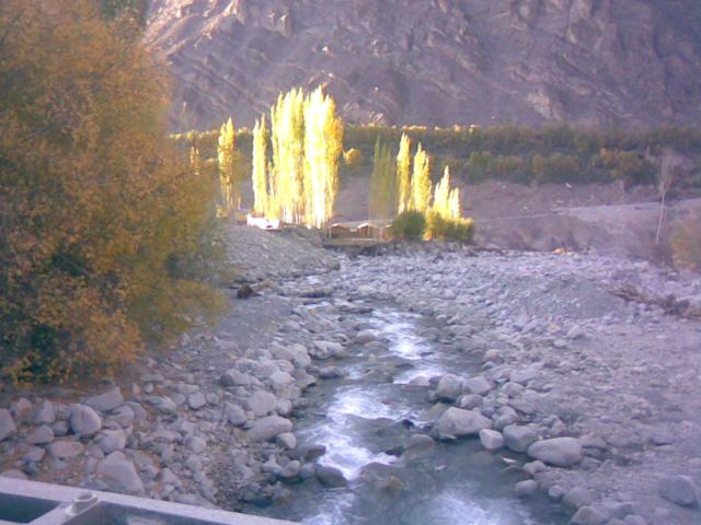
Age No Bar – 16 or 60 12/10/2010 Nurla Khaltse Lamayuru Fotu La Mulbek Kargil ( 160 km ) The UP boy prepared good…
Read More
Jhakri-Kaza-ChandraTal-Gramphu-Tandi-Keylong A good traveler has no fixed plans, and is not intent on arriving- Lao Tzu 23/09/2010 Jhakri Jeori Sarahan ( 38 km )…
Read More