
Though the entire Kumaon region is divinely beautiful, Kausani & Gwaldam are the authentic highlights due to its spectacular landscape with 300 km panoramic view of the range of Himalaya’s few of the very high peaks at hand shaking distance. The Nanda Devi and Trisul are the main attractions that attract tourists from far and near to glance the breathtaking scenic splendor at dawn which is unparallel. Mahatma Gandhi has rightly called the place the ‘Switzerland of India’. Located amidst dense Pine forest atop a ridge at an altitude of 1900 m, Kausani is a cool and tranquil place with limited tourist turnout hence still raw, retaining the natural essence.
On the way we found an interesting place called Garampani, with no hot water though, a village on the bank of a stream. A small restaurant, the NATURE, across the stream connected through a Jhula (bridge) forced us to stop and enjoy the wilderness while relishing the bread-omelet and tea. Innumerable fish in the stream attracted other travelers too clicking photos and so did my camera. Organic farming is supposedly being promoted by the environmentalists in the area with zeal because we found a few many at many places in Kumaon including here.
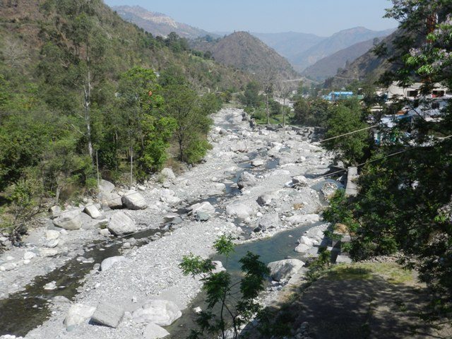
View from Garampani

Way to Nature Restaurant

Organic Farming at Garampani

Fishing Prohibited
After traveling almost 70 km from Nainital on the Bhowali-Almora well maintained road, appeared a sign board showing way to Almora on the steep straight road and a lane sloping down left towards Kausani. We were clear in mind to chose our way hence, after halting for a moment rolled down towards Kausani, another 50 km from that point. The road up to Kausani here onward is more scenic through the dense pine forest and rhododendrons and took us a little more than an hour to make it at or around 11 am.
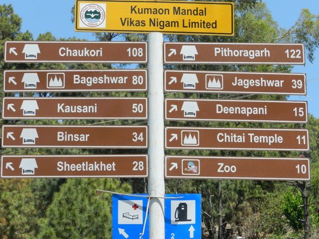
Places around Almora
There are a few resorts situated in and around Kausani but most of them are quite expensive and not affordable to stag ghumakkars like us with frequent ghumakkari. So, we spent some time in searching an ideal but affordable staying arrangement. Three of us therefore, started hunting in three directions. One of each came back with brief description and pictures in the mobiles and finally decided to check-in, in one of the best found, offering room facing the range situated at the edge of the valley on the road towards Baijnath with parking facility at a bargain of Rs. 1,500/-.

The Resort
The range of Nanda Devi and Trisul are not visible during day due to cloud and fog hence, we waited eagerly till the morning. The hotel we checked in was a kind of budget resort with nice cosy but spacious rooms, wall to wall carpet, neatly done bed and equipped toilet. Soon it was cold and the valley which was clearly visible from our room a moment ago, vanished in dense fog. After having our lunch, we strolled to the local sights viz. Gandhi Ashram also known as Anasakti Ashram where, Mahatma has written the Anasakti Treaty during his brief stay. Prayers are held here every morning and in the evening. A row of books of relevance and pictures on Gandhiji of pre-independence movements are kept here at perseverance. Another important place worth visiting is the Sumitra Nandan Pant Museum in commemoration of the all time great poet, writer, novelist and a premier in Hindi Literature. This museum displays his daily use articles, drafts of his poems, letters, his many prestigious awards etc.
Having visited the adobes turned museums of two great personalities, the instant influence spontaneously turned us patriotic, idealistic, poetic and also romanticist in the contagious romantic air in Kausani’s atmosphere, which none can escape. The place is so serene, fresh and alluring that mere walking around fills the heart with immense satisfaction and overwhelming exhilaration.
The night, on contrary was very starry and clear-fogless. Soon after having our dinner, we slept to wake up as early as possible to capture the awaited sight of changing landscape of the mountain ranges on the far end. Camera battery checked, alarm set, we slept with a wish to see a clear sky next morning. The hotel staffs informed about fog all day since a week. Early, much before it was dawn, we were ready with the camera staring at the far end in eagerness to witness the charismatic view and capture the majestic pictures of the magnificent Nanda Devi and Trisul peaks. Nanda Devi is the second highest peak in India with an altitude of 7816 m and the Trisul comprising three peaks appear like a trident hence called Trisul, are more prominently visible from here.
After a very long wait of almost 30 minutes i.e. 180 seconds, the first picture was taken, hurriedly thereafter, a number of clicks, till the sky was clear and the Sun was intense. Other enthusiasts with better and heftier cameras were using flash to capture the close-ups of their spouses and kids with the mighty range at the back drop. Pity, can’t help their better sense of photography but that definitely caused me miss the better moments to capture the frequent color change of the range and the varying landscape consequently, in my camera. Evidencing the nature’s charisma was like a blessing bestowed in bargain to the immense love for nature. We were in awe and sometimes even forgot to click the camera missing many worth frames. However, engulfed in a state of elation, we were ready to reach Gwaldam for another closer view of the Trisul. Gwaldam is only 40 km from Kausani via Baijnath on the way. The famous tea garden also lies just 5 km from Kausani on route.

View at Kausani

Trisul at Dawn

Nanda Devi Range

Range before Sun Rise

Range after Sun Rise
At 6.30 am we were passing by the tea garden, with tea plantation on the slopes with a processing unit situated there, which also provides information about tea processing. Having seen larger tea gardens of Assam and Darjeeling, it was of less interest to me however, the road traversing the tea plants on either side soothed the eyes. Road condition upto Baijnath is proper hence, we reached there in less than one hour. A halt here is inevitable to witness the ancient stone structures standing erect along left side of River Gomti. The ancient temple complex is a cluster of rock temples built by the Katyuri Kings in 1150 AD and dedicated to Lord Shiva mainly with idols of other deities like Ganesha, Parvati, Chandika, Kuber, Surya and Brahma also It is believed that Lord Shiva married Parvati in the confluence of River Gomti and River Garur Ganga hence the place is of much reverence and importance. The ASI has declared the site as protected monument thus safe under its supervision. Photography inside the main temple which is only where worshiping is performed now is prohibited. A board on the main entrance however, claims the temple premise constructed between 9th to10th centuries. After praying and bowing heads we were back on wheels.

Baijnath Temples

Main Temple at Baijnath

Baijnath Temple Cluster
The road from here onward was in bad condition and let me caution you that the local Jeep drivers are ruthless and drive mercilessly with no traffic sense and no courtesy. They may hit you desperately if you try to overtake even if they are driving dead slowly. They stop at any point without signaling in the middle of anywhere for dropping or picking passengers and rarely allows you to pass by them. We confronted some narrow escapes and also a couple of fights physically when we had to come out and beat one of them who was trying to play foul by signaling an over take and then pushing us towards the slopes and laughing triumphantly on our condition. Very few private vehicle ply on this route and mostly dominated by the overloaded taxis.

Bad Road Gwaldam-Karnaprayag
We finally reached Gwaldam safely with God’s grace. Much before reaching Gwaldam the enchanting view of the massive Trisul in magnitude appeared and disappeared all the way as if playing hide and seek and challenging to reach closer and closer and shake hand with its magical and glittering white peaks. Stubbornly, we too followed it accepting the challenge and participated actively in the game, finally reaching the point we were awaiting for a hand shake. The mighty Trisul was humble enough to greet us hospitably and seemed smiling on our childish stubbornness. It was an ecstasy to find the peak so close and so massive which was so far away only a few minutes ago. Click-click-click and the camera busy in its job. Soon a big dense cloud covered the entire range like a blanket teasingly asking us to go away and come again later as it was too much of intimacy for so long.

Range from Gwaldam

Trisul at Gwaldam

Good Road at Gwaldam
Journey is important and not the destinations! Planning, preparing and plying on the road to reach the destination are more thrilling and fulfilling than to finally reaching there. I remember how happy I felt while buying the crackers during Diwali and how sad after burning them during childhood. I was charged because a long distance through very important places in the Kumaon was still to venture on the return journey. We have chosen to come back via Gochar-Karnprayag-Rudraprayag-Devprayag-Rishikesh-Delhi covering almost another 500 km.
The road from Gwaldam upto Gochar at some stretches was in bad to worse condition and quite risky at some places with frequent landslides and steep gradients which require a very cautious driving however, the very low traffic was an advantage. The onward journey from Karnprayag on NH-58 is very picturesque and traversing the mighty rivers over the Iron bridges with breathtaking view is like driving in the paradise. The road to Badrinath and Kedarnath diverts from Karnprayag further on NH-58. via Nandprayag, Chamoli and Joshimath, the Valley of Flowers and Hemkunt Sahib can also be reached by this road. NH-58 is also important because it reaches upto the Tibet Border on Mana Pass commonly known as Delhi Road or Mana Pass Road. (I wish to drive upto there someday). Mana is a small village on the Mana Pass Road and it is believed that River Saraswati originates from there which is extinct at the Sangam (Allahabad) my home town.
After a three hour scary drive, we reached Karnprayag and decided to finish our lunch and fill the tank with fuel. A massive landslide just a few moments prior to reaching the spot near Dungari on Gwaldam-Karnprayag road shattered our daringness and turned us pale in sheer fear however, firmed our belief on God. We were saved by Lord Shiva, worshipped by all of us at Baijnath even though we were in a hurry to reach Gwaldam.

Land Slide Goaldam-Dungari
Karnprayag is situated at the confluence of River Pindar originating from the Pindari glaciers and River Alaknanda another Himalayan river considered rising at the confluence and foot of the Satopanth and Bhagirath Kharak glaciers. Mythologically it is important because it is one of the five Panch Prayags, others being Vishnuprayag, Nandprayag, Rudraprayag and Devprayag.

Karnaprayag

Tunnel to Char Dham Yatra
After finishing our lunch, we decided to not speak about the landslide incident in our homes. Karnprayag is a small but bustling town because of it being the junction with diverging roads to different directions. A tunnel is the gateway for reaching the Chamoli region. The NH-58, quite well maintained, (not aware of its condition after the unfortunate natural calamity in June’13) offers some excellent breathtaking views all the way along the mighty River Alaknanda. Driving on the entire stretch was so satisfying and enthusiastically refreshing that I never experienced any fatigues. Cris-crossing the cantilevers constructed over the Alaknanda by the BRO, changes the position of the River from left to right and vice versa. After driving on steep-ups, the river seems flowing deep down timidly and calmly in no hurry then on reaching at its level it suddenly appears with all its might, roaring and hurling, furiously showcasing the unbeatable power of nature.

Bridge over River.Alaknanda

A Cantilever (Jhula)

Cris-Cross of R. Alaknanda

Road along R.Alaknanda
After a pleasant drive of few kilometers, we reached another important place on route i.e. Rudraprayag, situated at the confluence of River Alaknanda and River Mandakani which originates from Chorabari Glaciers near Kedarnath and together flows onward violently. Rudraprayag is a revered Hindu pilgrimage due to its mythological importance and many ancient temples primary of which is the Rudranath Temple at the confluence, dedicated to Lord Shiva. A road from Rudraprayag on NH-109 leads towards Gaurikund, the dead end and base camp from where a tough trek along R. Mandakani reaches the most sought Kedarnath Yatra. Due to its religious importance and many temples, the place is crowded with very slow moving traffic predominated by local buses and jeeps plying overloaded but following the minimum traffic rules due to presence of traffic police at some points.

Confluence of R. Alaknanda & R. Mandakani
In one hour or so we escaped the jam packed town and back on the highway, the road condition was a mix of plain to small potholes as well as large creeks at some surprise points. The landscape changes from here, from the Himalayan to hilly because of the lowering altitude and much forested along the roaring furious river which after gathering volume from its tributaries on the confluences seems flowing more powerfully while descending towards the plains. Enjoying every bit of nature’s unprecedented magic and witnessing the live exhibition of ever changing scenery we soon reached Devprayag, situated at the confluence of River Alaknanda and River Bhagirathi.
Devprayag though a small town in the Tehri-Garhwal region, it is of immense importance due to the origin of the most holy river of the Hindus i.e. River Ganga that emerges from the confluence of the two rivers. Bhagirathi originates from two sources viz. Gaumukh at the foot of Gangotri glaciers and Khatling glaciers in the Garhwal Himalayas. Gaumukh is also considered to be the origin of River Ganga however, the Ganga is named only at Devprayag after the confluences gathering volume from its tributaries all the way. Like the other Panch Prayags, Devprayag is also visited by large number of devotees to pay obeisance to the number of temples of deities of Hindu faith, primarily to the Raghunathji Temple. People also come here for a holy dip at the originating point of River Ganga at the confluence.

Confluence of R. Alaknanda & R. Bhagirathi

Mighty River Ganga
A long awaited dream came true, years before conducting this memorable journey, I remember of buying a Road Map of India, a book by TTK with a blue plastic cover on it. It was one of my most favorite time-pass those days navigating through all the places in India and lost in imagination of visiting those places some day.
There are plenty of constructions on the banks of the river all the way obstructing its free flow. Dams, Temples, Houses and many Hotels built at the banks by cutting the edges diverting the age old natural passage of the river are the man’s biggest errors to overpower nature’s will. Probably these contributed in frequent natural calamities in the region in the recent pasts.

Man vs Nature

Woman At Work
The circular journey venturing the forest, lakes, snow peaks and divine ancient architectures as well as driving through good-bad roads along the mightiest rivers and witnessing their confluences in the enchanting Kumaon was finally stalled at Rishikesh with a feeling of pride and satisfaction. We stopped after driving whole day at 8 PM and stayed a night at Panchkula Bhawan on Rishikesh-Haridwar road to be back on road to reach Delhi after a holy dip in Haridwar next morning with promises to start the journey soon again and quench the never ending thirst of ghumakkari.

enjoyed your journey !
Dear Mahesh,
Thanks for accompanying.
Keep traveling
Ajay
Nice Post…..
Photos are awesome .
Dear Naresh,
So nice to hear such good words. Feels good.
Keep traveling,
Ajay
awesome log… with beautiful fotos
Hi there!
Thanks for liking.
Keep traveling
Ajay
Shaandar Post ………….
Dear Mukesh,
Thanks buddy for the appreciation.
Keep traveling
Ajay
nice post , nice photo
Dear Kamlansh,
Thanks for the good words.
Keep traveling
Ajay
That was indeed a long drive Ajay.
Kausani is a wonderful place to be if one loves upper Himalayas, not too many people, one can just be there and do nothing. Made me remember our trip of Kausani. Since I frequent Bhimtal area, some of the roads around Almora/Chitai/Binsar are very familiar and I was driving alongside :-)
The incident near Gwaldam is scary. I think each city has their share of unwanted people but in this case, it seems more than just a nuisance. I do not enough to comment and probably you guys would have done the right thing but it is not worthwhile to engage in any kind of road rage. you never know.
Drive back home, via the long and circuitous route was enjoyable.
Hope your Gujrat tour is going fine. Wishes.
Hello!
Sorry for replying late. As told, I was on roads from 5th & returned after a 6500 km drive around Gujrat in 20 days. Enough stuff to narrate as time permits.
Thanks a lot for all your supportive words.
Regards
Ajay
How is the road condition from Delhi to kausani after the calamity in June last year. Would like to visit inJun2014
Mr. Singh,
The devastation was mainly caused in Garhwal region, the Kumaon region was not much affected. The road condition from Delhi-Rampur is extremely good. Rampur-Rudrapur a 40km stretch is single. Rudrapur-Bhowali on good tar, Bhowali-Kausani via Almora or Ranikhet is a hilly terrain but negotiable with self drive. Avoid returning via Gwaldam because the road condition is worse at some patches and so is the traffic, dominated by local taxis.
Keep traveling
Ajay
you guys are spoiling me, pushing me to just run away from home.
Which was the hotel at kausani you stayed in and is it recommended for family stay.
I simply love your blog because it provides better information than sites like yaatra, makemytrip, etc. keep it up.