
Day 4: Wan (वाण) – Bedini Bugyal (बेदिनी बुग्याल) (12 km, 6.00 am – 11.00 am), on foot, Trek Level: Easy to Moderate
We got up at 5.00 am and after getting ready and having Maggi as breakfast (first time in my life), we left at 6.30 am for Bedini Bugyal, 12-13 km away at a height of 3400 m. Now I carried a small rucksack where as guide and porter carried rather big bags. When we started climbing the mountain, the weather was pretty good. On the way, found some small huts, wall-nut trees and many plants with nice little flowers. It was very scenic as one can imagine. The path was 1 m wide stony and gravely route, slippery due to rain, not too steep yet but one could now feel what is it like trekking at higher altitudes. Short breaks were taken to breathe before resuming trekking again. It is not easy walking on such paths and one needs to be careful to avoid any injury. First long-ish stop was at a place called Ranak Dhar (height not known but may be 3000m), about 2 km from Wan and on a hill-top. It was very cloudy and one could not see far enough.
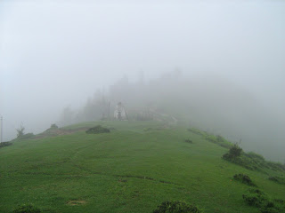
Ranak Dhar (रनक धार ) peak top, first stop away from Wan; a small temple can be seen which are common on the hills
After having some water, candies, we started downwards towards ‘Neel Ganga’ river which flows between two mountains; on one side Wan and another side Bedini Bugyal. The river was about 2-3 km downwards from Ranak Dhar. At Neel Ganga, another short break was taken to recover and to take some more snaps of the beautiful surroundings. Downward journey was reasonably steep and could be quite difficult due to bad road and can be quite severe on ankles and knees.
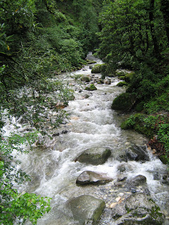
Neel Ganga (नील गंगा ) river parting Wan and Bedini
From Neel Ganga, it was about 7 km steep uphill trek. The road was narrow, but since it was in the jungle so not so dangerous if one falls. However slippery and rough character of the trekking path meant that it was quite difficult. But as I went higher and higher, breathing became more and more difficult and we needed more short stops to recover and start again. After about 4 km steep uphill trek, we reached a place called Gairoli where there is a small temple (they are everywhere in hills) where my guide and porter prayed. I had some tea in the meantime and had a stroll to see nearby scenery which was awesome. We were still among trees, mainly Buransh and Khairu but soon were about to enter into a terrain which was way too high to have any trees. On this route, we also met 3-4 returning tourists and only one of those could reach Roopkund, explaining the difficulties due to bad weather, snow and glaciers.
Gairoli Patar (गैरोली पातार ), stop between Neel Ganga and Bedini
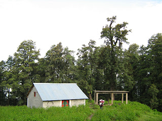
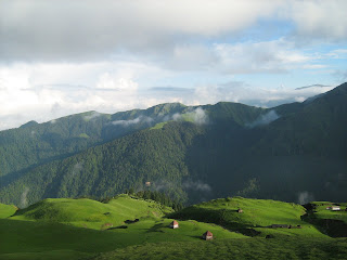
After Gairoli, we moved towards the final destination, about 3 km away. Again, it was a steep uphill trek, making breathing more difficult but the mere view of the whole place does not let one tire. We kept moving, though at a slower pace, until we could reach rather less steep uphill trek which is about 1-2 km from Bedini. This is where trees disappeared and the terrain became rocky or grassy. Looking down the hill can make one nervous, if one falls then one can only think of death. Anyways, soon after, I could see Bedini Bugyal with its massive lush green landscape at a height of 3500m, where for most of the year no one lives, except rocks, grass and may be some birds and animals. Bugyal means lush green lawn in local Pahaadi language. Bedini and its neighbour Aali Bugyals are one of the biggest green tops found on mountains in the entire world, sitting at 3500 m or so. At Bedini, there is a tourist hut (with no furniture or facility) which is availed at Rs 300/- per day if empty. We reached Bedini at about 12.30 am, covering in 6.00 hours which is not bad considering we carried quite a bit of stuff with us. However, I still was feeling alright with not much altitude sickness except a little headache which was taken care by a small dose of Dispirin. Since, I went in a season when not many tourists came, we got the hut from the attendant Mr Khatri. My guide and porter started preparations for lunch and I went out to enjoy the nature and take some pictures. Clouds were hovering on top and from my short stint so far, I knew it would start raining soon.
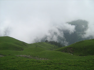
Bedini Bugyal ( बेदिनी बुग्याल ) under clouds
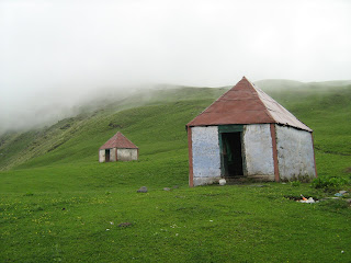
Cottages at Bedini, one for tourists and another for the care taker
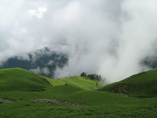
Another view of Bugyal under part sun and part cloud
The temperature at Bedini was about 12C in day, not too bad, eh! The walk on the Bugyal was refreshing and the view of the small mountains on one side, snow-capped mountains, Nanda Ghunti (6309 m) and Trishul (7120 m ) on the other side was simply amazing. When clouds were clearer, one could also see Neelkanth and Chaukhambha, far off snow-capped peaks. Underneath, the view of the tree-cladded green valley with clouds hovering on it was simply fabulous. In summary, it was simply heaven. I could also see a few shepherds who came to Bugyals in summer to find some Ayurvedic herbs and then went down in winter. In summer, shepherds also brought along their cattle with them to feed on abundantly available lush green grass and crystal clear water coming from not so distant glaciers.
Soon it started to rain and we all got into the hut and had some tea and lunch. Then we crashed to our mattresses and had a little nap. It kept raining almost all day and I had no option but to sit and keep staring at the nature from my hut. Finally we slept off early. Getting good sleep was necessary but not easy as it was cold and wet and getting a good sleep in an unknown place for the first time can be difficult.
Day 5: Bedini Bugyal (बेदिनी बुग्याल) – Bhaguabasha (भागुआबाषा) (12 km, 6.00 am – 11.00 am), on foot, Trek level: moderate to difficult (easy at the end for about 1 km)
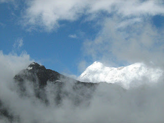
We woke up at about 5.00 am and I ventured out to see sunrise. To my surprise, sun was there and the morning view was simply amazing. I could see Nanda Ghunti and Trishul very clearly along with a view of Roopkund in the far off mountain at Trishul base. At times, it was possible to see far off snow-capped peaks of Neelkanth and Chaukhambha standing majestically on the earth.

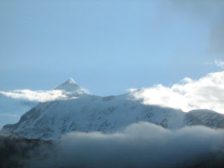
Trishul (snow-capped one at the back, 7120 m) and hills before.
Nanda Ghunti (6309 m) in the morning as seen from
Neel Kanth (नील कंठ right) and Chaukhambha (चौखम्भा left) viewed from Bedini
Morning view of Bedini Bugyal and hills facing
We soon packed our stuff and moved on towards Bhaguabasha, भागुआबाशा 12 km away from Bedini and last base before Roopkund and is mainly a Rocky terrain with snow। The trek to Bhaguabasha is rather difficult due to high altitudes making it difficult to breathe. We started at 6.15 am. This route was very scenic in beginning: on one side majestic mountains and on another side downwards sloping green Bugyals. The way to this route was difficult, rocky as well as risky, one is always in the danger of falling if not careful. We met two returning tourists hailing from Mumbai who could not see Roopkund, again due to same reasons. First we reached a stop from where one can go to Patar Nachuni, a halt preferred by some over Bhagubasha. After a few minutes, we started to climb Kalua Vinayak which is higher than Bhaguabasha and the trek is really steep, difficult with narrow and very gravely and slippery paths. This was indeed a difficult bit of trek but we made it to Kalua Vinayak at 11.15 am where there is a small Ganesh temple where we paid our reverences. It was also very cold and windy on top of Kalua Vinayak. The perspiration due to trekking started to bite. The view on the Bedini side of Kalua was lush green Bugyals and towards Bhaguabasha was rocky mountains with no life and only snow and rocks, quite a contrast. Soon, we started to move towards Bhaguabasha which was about 1 km slightly downhill from Kalua Vinayak. On the way, we found small patches covered with snow, which were quite slippery due to rain. We reached Bhaguabasha at about 12.00 noon and the sun was out. The view of the Trishul peak and glaciers on it was simply amazing. I just found myself lost a bit in this place. A bit of headache due to altitude was there and again Dispirin did a wonderful job.

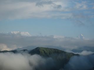
Another view of the valley under clouds
Roopkund (front) and Trishul (Back) from Bhaduabasha
We quickly unpacked our stuff and put on the tent as rain was looking imminent. Surendra soon started making tea and preparations for the lunch. We had some nice hot tea followed by a Khichdi meal. Rain kept pouring in forcing us to sit inside the tent. It was quite cold too with day temperature around 7-8 C. In between we had a short nap and then in evening I stepped out to see the views which were looking marvelous as ever. However rain did not allow us to enjoy the nature for long. Soon it became dark and then night arrived. We slept off again very early. In the night, I noticed that temperature fell down to about 1 C, quite chilly!
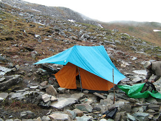
Our tent at Bhaguabasha
Part III: Final summit to Roopkund and return
Pictures on http://photos.ibibo.com/album/79615/1/trek-to-roopkund
bahut kathin chadhai malum hoti hai.
Ashish – I am surprised to see just 1 comment for such a story full of grit and beautiful pictures. Try responding to comments please. That keeps the conversation going.
I first heard about Roopkund from a fellow Ghumakkar, Ajeet. Not sure whether you have read some of his works. It is at – https://www.ghumakkar.com/author/ajeet/
He did mention the bugyals but I didn’t know that these are one of the world’s largest. If one is able to reach Wan then probably the trek to these bugyals would be extremely worthy. I am asking these questions because I might get opportunities to be in Nainital area for many days for next many years. And having these weekend trips during those times might have a greater possibility than doing it all from Delhi.
@Vandana: Chadhai utni kathin naheen hai jitni dikhti hai.. worth trying.. Koi information chahiye to contact kijiyega..
@Nandan: I think most people seem to reply at the last post… Yes, these bugyals are the biggest in and really beautiful, especially when it is sunny. From Wan, you can go up in a day and some back next day.. I think there is a rest house of tourism dept at loharjung.
?? ??? ?? ?? ?? ???? ?????
hello ashish
..i dont know weather you are active on ghumakkar or not..but if you read my this comment than please help me as i am going on roopkund track around first week of November..still i am in dilemma that route are open or not till roopkund..i tried to contact many people on those area but failed..if you have any contact number of guide please give me..
Thanks for quick reply….